URL : https://www.valka.cz/SOV-RSBN-4N-radiotechnicky-system-blizke-navigace-t41759#220442
Version : 0
RSBN-4N near navigation radio system
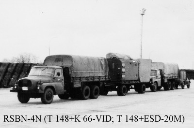
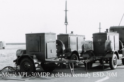
The ground equipment is stored in a set during transport. Kit composition: - 2 cars Tatra T-148 VNM, (carrying wiring, antenna, current converter VPL-30MDP - 1 two-axle lift with K 66-VID cab, - - 1 trailer with EC ESD-20M. ***
a) Azimuth channel transmitter power: continuous 80 W, pulse 30 kW frequency band 873.6 - 935.2 MHz; b) rangefinder channel transmitter power: pulse 30 kW frequency band 939.6 - 1000.5 MHz. c) The receivers operate in the band 770.0 - 812.8 MHz.
It can provide an unlimited number in the azimuth channel, in the rangefinder up to 100 aircraft.
The range of the system is similar to RSBN-2N . The system can be controlled locally or remotely up to 30 km. The portable VIKO can be placed up to 30 km (MT-15S on a 10 m mast).
The crew of the system consisted of a chief, 2 technicians, 2 electromechanics, 2 mechanics and 2 drivers/engineers of the power plant.
Source: MNO - "RTZ systems and means" - aid Let-51-70 - 2nd edition R. 1982
Period
-
Type
-
Camouflage
-
Country
-
Production No.
-
Poznávací značka / evidenční číslo
-
Tactical marking
-
Name
-
Unit
-
Date (DD.MM.RRRR)
-
Author
-
Print size / 300 DPI
-
Published with authors permit
-
Author Website
-
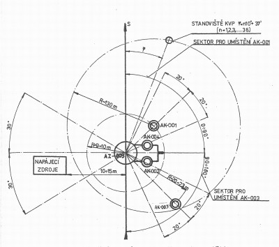
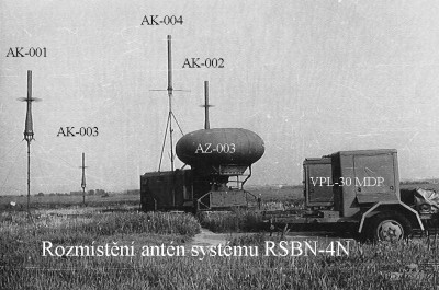
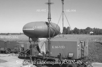
Půdorys rozmístění systému
Period
-
Type
-
Camouflage
-
Country
-
Production No.
-
Poznávací značka / evidenční číslo
-
Tactical marking
-
Name
-
Unit
-
Date (DD.MM.RRRR)
-
Author
-
Print size / 300 DPI
-
Published with authors permit
-
Author Website
-
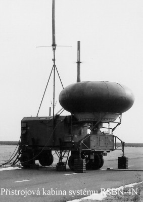
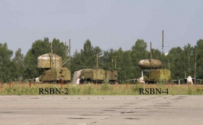
Celkový pohled na soupravu RSBN-4
Period
-
Type
-
Camouflage
-
Country
-
Production No.
-
Poznávací značka / evidenční číslo
-
Tactical marking
-
Name
-
Unit
-
Date (DD.MM.RRRR)
-
Author
-
Print size / 300 DPI
-
Published with authors permit
-
Author Website
-
Souprava RSBN-4 za přesunu
Period
-
Type
-
Camouflage
-
Country
-
Production No.
-
Poznávací značka / evidenční číslo
-
Tactical marking
-
Name
-
Unit
-
Date (DD.MM.RRRR)
-
Author
-
Print size / 300 DPI
-
Published with authors permit
-
Author Website
-
Další záběr soupravy
Period
-
Type
-
Camouflage
-
Country
-
Production No.
-
Poznávací značka / evidenční číslo
-
Tactical marking
-
Name
-
Unit
-
Date (DD.MM.RRRR)
-
Author
-
Print size / 300 DPI
-
Published with authors permit
-
Author Website
-
Přístrojová kabina
URL : https://www.valka.cz/SOV-RSBN-4N-radiotechnicky-system-blizke-navigace-t41759#292133
Version : 0
Reklama
All photos are from our own archive
Period
-
Type
-
Camouflage
-
Country
-
Production No.
-
Poznávací značka / evidenční číslo
-
Tactical marking
-
Name
-
Unit
-
Date (DD.MM.RRRR)
-
Author
-
Print size / 300 DPI
-
Published with authors permit
-
Author Website
-
Zdroje proudu soupravy RSBN-4
Period
-
Type
-
Camouflage
-
Country
-
Production No.
-
Poznávací značka / evidenční číslo
-
Tactical marking
-
Name
-
Unit
-
Date (DD.MM.RRRR)
-
Author
-
Print size / 300 DPI
-
Published with authors permit
-
Author Website
-
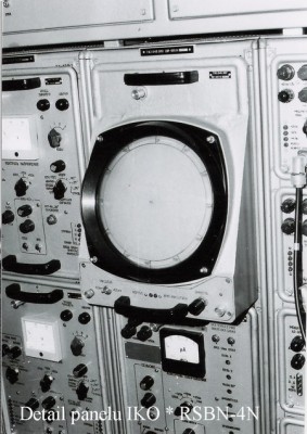
Výnosný indikátor obzoru
Period
-
Type
-
Camouflage
-
Country
-
Production No.
-
Poznávací značka / evidenční číslo
-
Tactical marking
-
Name
-
Unit
-
Date (DD.MM.RRRR)
-
Author
-
Print size / 300 DPI
-
Published with authors permit
-
Author Website
-
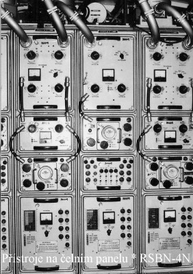
Přístrojový panel
URL : https://www.valka.cz/SOV-RSBN-4N-radiotechnicky-system-blizke-navigace-t41759#292136
Version : 0
The RSBN system is designed primarily for bomber, fighter bomber and transport aircraft and provides navigation of aircraft equipped with on-board equipment RSBN-2S, or its modifications (RSBN-5S, RSBN-6S).
The system provides in all weather conditions day and night: Continuous information to the aircraft crew about the position of determining the polar coordinates of the aircraft (azimuth, distance) on the ground and on board, bringing the aircraft to any designated point (destination) in the range of the radio beacon with signaling) of the moment of approach and the moment of its flight, ground monitoring of the air situation on the overview screen (IKO/VIKO), determination of coordinates and identification of aircraft on the screen using the system, correction of autonomous flight path computers and automatic flight as well as connection with aircraft.
The system consists of on-board and ground equipment.
Brief description of activities: a) Determination of the oblique distance - a pulsed radio rangefinder with the principle of "Question - Answer" from the aircraft deck is used b) Determination of azimuth - azimuthal transmitters are used (azimuthal rotating antenna is in the windshield) c) Determination of coordinates on the screen - the principle of inquiry from the ground and answers from the aircraft deck is used. The position of the azimuthal antenna to the north is derived from the sensor "180" by 2 °. d) Aircraft identification - performed by sending a command to the pilot. He presses the "Opoznavanie" button and "doubling" appears on the IKO (VIKO) next to the aircraft mark.
Source: MNO - "RTZ systems and devices" - aid Let-51-70 - 2nd edition R. 1982